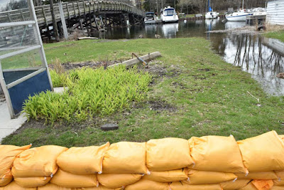
The Toronto Region Conservation Area has a shoreline hazard warning in effect from April 30 till May 8, 2019; "This Shoreline Hazard Warning applies to areas along Lake Ontario, and does not apply to conditions along rivers in the TRCA jurisdiction. The International Lake Ontario – St. Lawrence River Board is forecasting that water levels for Lake Ontario are expected to continue rising until late May or early June . The current Lake Ontario water level is approaching 75.5 m (IGLD 1985 Datum) at Fisheries and Oceans Canada’s tidal observation station at Toronto. For reference, the observed water level for the month of April at Toronto in 2017 reached 75.58m, and the maximum observed (daily) water level during the entire Lake Ontario event in 2017 was 75.93m. Additionally, winds gusting up to 60km/h from the east are expected to bring offshore waves >2.0m in height on Wednesday May 1st."
Quad bikes are back on the island
Sand, shovels and bags stand at the ready
Ferry rides to the Island are inexpensive and a fun way to start your trip
Pumps send the errant water back from where it came
The sign along the road cautions about the high water level and says leave no wake
The roadway is marked by metal stakes along the edges


No comments:
Post a Comment