Showing posts with label water. Show all posts

Sunday, December 12, 2021

Unusual Winter Storm blows into Fort Erie

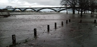
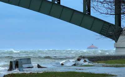
Windspeeds of 69km/h starting around 5pm on Saturday, December 11 whipped up Lake Erie and pushed down the Niagara River into Fort Erie, taking out power and flooding the area around the Peace Bridge. Temperatures peaked at 1pm with an astounding 19 degrees Celsius; it was balmy in the early part of the day until the blowing winds gusting approximately100 km/h rapidly brought down the temperatures and quite a few trees and assorted tree parts causing many power outages. These conditions were also experienced throughout much of Southern Ontario.
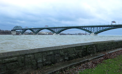
The sea wall along the Niagara River
The wind whipped up the water level and produced high waves that quickly pushed over the wall along the river's edge. You can just see the top of the wall near near the bridge in the photo above

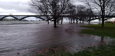
The Niagara Parkway was closed under the famous crossing between Canada and the United States as the area is prone to flooding. At first the high water levels and waves splashed against the concrete and block wall along the river, then the water gradually started to creep overland and onto the parkway. In the photo at top you can see the water as it starts to fill the parking lot at the foot of Queen Street, just off the Niagara Boulevard.
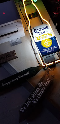
A lot of Fort Erie's power was out when we went into Southside's Patio, just before the power went out

Niagara Peninsula Conservation Authority's December 10th special weather statement identified the following hazards; "Niagara is currently under a Special Weather Statement as issued by Environment Canada, calling for strong southwest winds gusting between 90-110km/hr beginning tonight and continuing on into Saturday evening. These strong southwesterly winds will increase water levels and waves along the entire Lake Erie shoreline. The Ministry of Northern Development, Mines, Natural Resources and Forestry is currently predicting water levels to increase above current levels on Lake Erie by approximately 1.8m (6.0ft), to an elevation 176.3m. Significant wave heights of approximately 1.8m (6.0ft) are also forecasted to occur all along the entire Lake Erie shoreline during this time. Water levels are forecast to peak Saturday evening around 8:00pm."

As of 6:30pm Dec 11 the Town of Fort Erie had posted the following road closures on their facebook page.

"The following roads are closed due to flooding, trees or power lines down. Please use a lot of caution if you have to be out.
- Point Abino Road south of Erie Road
- Ridgeway Road at Crystal Beach Drive
- Lake Avenue at Crystal Beach Drive
- Terrace Lane
- Niagara River Parkway from Central Avenue to Queen Street (NPC)
- Lakeshore Road from Albert Street to Central Avenue
- Nigh Road from Mathews Road to Highway 3
- sunset Drive Garrison Road to Gilmore Road
- Bertie Street Pettit Road to Sunset Drive
- Thunder Bay Road Windmill Point Road to Nicolas Avenue
- Shirley Road Thunder Bay Road to Bethune Avenue
Crews are out working hard to clear the debris."

Thursday, August 27, 2020

Big Bend Lookout and the Big East River

The Big East River starts in Algonquin Park and heads to Lake Vernon near Huntsville, twisting and turning especially as it flows near and through Arrowhead Provincial Park. As the fast flowing water cuts through layers of sand it causes the formation of oxbow lakes and loops in the river and the lookout in the provincial park provides an outstanding view of one of the great loops in the river.


Arrowhead Provincial Park is 2.5 hours north of Toronto and is part of Ontario's primo cottage country called Muskoka. In addition to the camp sites and beaches, the park has two great points of interest - Big Bend Lookout and Stubbs Falls on the Little East River.

Panorama of Stubbs Falls on the Little East River

When rivers are allowed to determine their route (not constrained by man) they tend to follow the past of least resistance, from high elevations to low elevations. Sand does not stand up to the flow of water very well and erosion in sandy areas is quite extensive and the river meanders, causing some areas to be cut off from the river and be turned into oxbow lakes or even dry up, hiding the past river channel. Big Bend Lookout has large sand slopes along the outside of the curve, cut by the current, while sand is deposited on the inside of the curve as the water slows and the sediment falls out of the water. Erosion of the outer bend forces the park to move the lookout back from the edge each year. The view is similar to the famous Horseshoe Bend in the Grand Canyon.

Upstream launch point at Arrowhead Park Road adjacent to Highway 11
Cruising down the river

One of the reasons we came to Arrowhead was to kayak down the Big East River which flows fast enough that it is almost lazy river quality if you head downstream. We decided to drop the kayaks on Arrowhead Park Road adjacent to Highway 11. There is a small parking lot near Tulip Inn where you can park for free during the day. Then we parked our other vehicle at Hutchenson Beach at Lake Vernon which also had free parking. Light paddling and a stop for a barbecue lunch on one of the many sandbanks along the river had us completing the journey in about 5 hours and a distance of about 10 kilometres. It was a great journey and we hope to do it again next year. Highly recommended.

Stopping for a barbecue lunch on one of the many sand beaches along the Big East River
Spring runoff make for a powerful river. These steps got caught up on fallen trees

Update August 2021: We made it back to the Big East River, this time traveling down stream between Williamsport Road and Highway 11, passing through the famous Big Bend Lookout in Arrowhead Park. Last year we looked down upon the river and decided that we needed to put on our pirate hats and rest up on the sand bank below the lookout.
Pirates approaching the Big Bend

See more of the journey after the jump.

Friday, August 21, 2020

Toronto's Humber West Recreational Trail

The city has many kilometres of multi-use trails - some of my favourites are the Don Valley Trail, the Lakeshore Trail and now the West Humber Rectreational Trail. You can ride from Highway 427 and Finch through the North Humber Trail, the Mid-Humber Trail and finally down along the Lower Humber River Trail till you get to the Humber Arch Bridge which is a distance of about 35km. The path is paved and about three metres wide.


We parked at the Humber Arboretum, just off of Finch Avenue and headed south along the trail which ends at the shores of Lake Ontario. The trail is actually signed with route markers within the trail system. When the trails come to an intermediate terminal point you have to go on the streets to pick up the next trail portion. The only problem is where you hit the road there are typically no trail signs posted on the road, you have to guess where to go or if you have a phone with a data plan you can try to look up the trails on google maps.

Two deer enjoying the river valley

What is incredible about the journey is the natural forests and green spaces winding between stretches of municipal parks which include such jewels as James Gardens, the Arboretum and the Humber Bay parks along the lake. On our ride back we saw two small deer eating shrubs near the Arboretum. I was surprised that we were about 50 feet away from the deer but they weren't too scared of us and they kept eating while a small crowd gathered to watch the wild animals.

During our trip there were lots of families enjoying barbecues and playing in the river and when you hit the lake area the amount of people riding the path across the Humber bridge and along Lake Shore Blvd West was quite high during an ActiveTO weekend event.

The trails are posted and numbered and the ones we followed were #15 and #40, you can see where they branch off to connect mid-trail to adjacent roads, or go towards another side trail. I haven't found a map yet which shows the bike route numbers. During this route we passed under the long bridges for Highway 401, Gardiner Expressway and the Lake Shore west railway line. The trail also had a number of pedestrian bridges crossing the river including one that had a wooden walkway over an old bridge footings.

Graffiti murals under Highway 401
The long staircase in Mallaby Park. It has a bike ramp along both sides


James Gardens

Saturday, September 03, 2016

Paddling in Guelph Lake

The lake may be a little low but it is a fine body of water to enjoy with your kayak. Ann and I have been trying out different lakes and rivers to find some places to enjoy nature and see some new sights, or the same sights from a different perspective. To kayak you only need a few things: a legal and safe place to park your car close to the water, a small slope where you can launch your boat, water that is not too slimy or muddy and where you can get in your kayak with a minimum of fuss, and if the water is clean and not to full of seaweed, score, a good day for fun on the water. Most of the creeks and small rivers do not have enough flow during summer to kayak very far.
After Rockwood and Lake Ontario we tried the Grand River, however the water was low during the heat of a long dry summer so we ended up constrained by rapids within a small area. Today we thought we would try a small man made lake made by damming the Speed River, a tributary of the Grand River, with a dam in 1974. The Guelph Lake Conservation Area is accessed from the north side of the lake and an entrance fee is charged at the gate. To launch the kayaks we were told to go to the Island Lake side and bypass the main beach. You can drive your car right down to the water and unload your boats, then find parking just off the beach. The high water line is seen in the photo at top where the white rocks meet the darker rocks.
Kayaks are a big hit with many people that want a little exercise and want to visit places a little less traveled. You don't need much water to paddle a kayak, you just have to watch out for big rocks and the stumps of trees that occasionally dot the underwater landscape. One thing you notice when you get near water - there are a lot of people that love to fish.

Low flow means the area leading up to the dam isn't that treacherous in late summer, so we park it along the high beach and walk up to the hill and get a great view of the lake. Coming back we see a Heron along the shore looking for small fish foolish enough to get within striking distance. It was a nice adventure and a great place to visit.

Wednesday, October 15, 2014

Frost brings the colour

October's long, cool nights have brought a lot of colour into the Greater Toronto Area. Forests of green have quickly started to show more yellow, orange, red and purple and this is the time to get out into nature before the leaves are all on the ground and blah becomes the colour of the day.


Doors Open

Scarborough Bluffs

Pride

Redball

Beaches

Graffiti

Lake Ontario

Nathan Phillips Square

Transportation