Showing posts with label travel. Show all posts

Sunday, December 12, 2021

Unusual Winter Storm blows into Fort Erie

Windspeeds of 69km/h starting around 5pm on Saturday, December 11 whipped up Lake Erie and pushed down the Niagara River into Fort Erie, taking out power and flooding the area around the Peace Bridge. Temperatures peaked at 1pm with an astounding 19 degrees Celsius; it was balmy in the early part of the day until the blowing winds gusting approximately100 km/h rapidly brought down the temperatures and quite a few trees and assorted tree parts causing many power outages. These conditions were also experienced throughout much of Southern Ontario.
The sea wall along the Niagara River
The wind whipped up the water level and produced high waves that quickly pushed over the wall along the river's edge. You can just see the top of the wall near near the bridge in the photo above

The Niagara Parkway was closed under the famous crossing between Canada and the United States as the area is prone to flooding. At first the high water levels and waves splashed against the concrete and block wall along the river, then the water gradually started to creep overland and onto the parkway. In the photo at top you can see the water as it starts to fill the parking lot at the foot of Queen Street, just off the Niagara Boulevard.

A lot of Fort Erie's power was out when we went into Southside's Patio, just before the power went out

Niagara Peninsula Conservation Authority's December 10th special weather statement identified the following hazards; "Niagara is currently under a Special Weather Statement as issued by Environment Canada, calling for strong southwest winds gusting between 90-110km/hr beginning tonight and continuing on into Saturday evening. These strong southwesterly winds will increase water levels and waves along the entire Lake Erie shoreline. The Ministry of Northern Development, Mines, Natural Resources and Forestry is currently predicting water levels to increase above current levels on Lake Erie by approximately 1.8m (6.0ft), to an elevation 176.3m. Significant wave heights of approximately 1.8m (6.0ft) are also forecasted to occur all along the entire Lake Erie shoreline during this time. Water levels are forecast to peak Saturday evening around 8:00pm."

As of 6:30pm Dec 11 the Town of Fort Erie had posted the following road closures on their facebook page.

"The following roads are closed due to flooding, trees or power lines down. Please use a lot of caution if you have to be out.
- Point Abino Road south of Erie Road
- Ridgeway Road at Crystal Beach Drive
- Lake Avenue at Crystal Beach Drive
- Terrace Lane
- Niagara River Parkway from Central Avenue to Queen Street (NPC)
- Lakeshore Road from Albert Street to Central Avenue
- Nigh Road from Mathews Road to Highway 3
- sunset Drive Garrison Road to Gilmore Road
- Bertie Street Pettit Road to Sunset Drive
- Thunder Bay Road Windmill Point Road to Nicolas Avenue
- Shirley Road Thunder Bay Road to Bethune Avenue
Crews are out working hard to clear the debris."

Sunday, December 05, 2021

Tiny Ball of GO Train in Toronto

Is it a GO Drone from Star Wars, searching for the rebel alliance's secret base? No, it is a GO Transit/Metrolinx art installation depicting a GO Train uniting Toronto to the rest of south and central Ontario.
The round ball is located at 16 York Street, just across from the Scotiabank Arena on Bremner Boulevard in Toronto. I waited a few hours in a line up of one to board the tiny, round train, my Presto card at the ready before I realized that this baby not only had no rails to run on, it had no door!

Wednesday, November 10, 2021

Wineries closer to Toronto than Niagara-on-the-Lake

Thousands from the GTA travel on weekends into the Niagara-on-the-Lake area, famous for its blend of wineries, scenery and lovely towns. Getting there is a scramble on the QEW which many times slows to a glacial pace, then you have to wait to get close to the tasting bars. Well, you can get off the path most travelled and enjoy the Bench and Niagara Escarpment areas from Beamsville to St. Catherines. 
Back 10 Cellars

I know one of Ann's favourite wineries is Angel Gate which is on the Beamsville Bench and the last time we visited I learned that Nuns used to look after the property. Then when it became Angels Gate they made the building look like a church or mission.

Grape vines on rolling hills

The BENCH Brewing Company
We found a Ghostbusters hearse
Spend some time watching the boats travel the Welland Canal in St. Catherines

Monday, November 08, 2021

Mini Train and Carousel in Guelph

The 80 acre park in north Guelph along Woolwich and Woodlawn Streets is a lovely park bisected by the Speed River, full of special features including the miniature train and carousel. The amusement rides are open daily from Victoria Day weekend to mid-September and during weekends only until early October (10:30am till 6pm).

Standing on the tiny railway track
Carousel building

The park hosts seasonal events including outdoor concert series at the amphitheater and in winter time the annual Rotary Sparkle in the Park returns December 16 to 31, 2021 (5:30pm to late).


You can also find rock gardens, children's playground, horseshoe pits, a windmill, a 9-hole disk golf course, a floral clock and walking trails. 

In autumn the park is full of vibrant colours. You can see more photos after the jump.

Sunday, May 09, 2021

Niagara-on-the-Lake is at Peak Blossom

NOTL has been a little behind Toronto in the development of cherry blossoms, which was opposite to what we thought would happen. The orchards and groves of cherry trees have slowly been perking up over the last three weeks. You could see the blossoms starting but no big explosions of colour except for the occasional magnolia trees.

McFarland House blossoms

Then we went on the trip into the St Catherines area and further southwest into the Niagara area we started to see colours in the orchards and in the many parks along Lakeshore and the Niagara Parkway. You can find plenty of pink blossoms at such locations as the Niagara Parks Horticultural School and McFarland House. For easy to access orchards one of the best locations is along Lakeshore just past the Welland Canal where you can park at MJ's Own Munchies restaurant, pick up lunch or dinner and take pictures along the edge of the orchard.


Orchards along Lakeshore Road

Sunday, January 10, 2021

Welland Canal sprang a leak

First they shut down the Welland Canal for the season, no big ships plying the H2O Highway between Lakes Ontario and Erie, then whenever they need to do inspection and maintenance they drain the water out between lock sections. In January 2021 the water between Locks 3 and 7 has been drained, leaving a small creek running down the canal.


Up at lock 7 they have heavy duty pumps sucking the water out of the empty lock and back into the upstream channel. The locks aren't really watertight and the ducks appreciate the slower flows.
The lift bridge at Glendale Avenue
The signs say don't use your anchor around the pipelines

The view of the empty canal is pretty amazing. It is hard to believe that those giant Great Lakes steamers can make it through without dragging their hulls through the dirt.

See more photos after the jump.

Wednesday, December 16, 2020

Welland Canal to close for season in Jan 2021

One of our favourite social distancing trips is to the Welland Canal watching the big ships transit the H2O Highway between Lake Erie and Lake Ontario. Not too far from Toronto and also close to the Niagara area's wineries and other attractions. We will miss when cold weather shuts down the canal and the ships hunker down and wait out the grip of Canada's ice. You can see where the canal is closed and parts of the highway have been drained on my post here.
Hinged bridges open as the ship closes in on the QEW's Garden City Skyway
During winter they often empty parts of the canal for maintenance purposes

Normally the Welland Canal closes by the end of the year (Dec 31st) but in 2019 they started a pilot program to keep the canal open a little longer. The season was pushed into 2021 by an extra week and all vessels must be clear of the canal by January 8, 2021.

The Great Lakes - St Lawrence Seaway System, SEAWAY NOTICE NO. 1 - 2021 issued Feb 15:
The opening of the 2021 navigation season is scheduled to take place on the following dates and times: • Welland Canal: March 19, 2021 - 0800 hours (D.S.T.) • Montreal / Lake Ontario Section: March 22, 2021 - 0800 hours (D.S.T.)

Monday, November 02, 2020

Rad Power Bike and Ontario Bicycle Trails

Now that I have an ebike I have been actively seeking out bike trails for some outstanding day trips that combine exercise and great destinations. An ebike allows you to go faster and farther that you probably go on a regular bike unless you are a Tour de France rider - just the ticket for me as I continue to age.

Biking inside the covered bridge
Kissing Bridge in West Montrose

I tend to bike a lot around Toronto because you can find one place to park (and save on multiple parking fees) and travel around the city without the hassle or expense of taxis, ubers and the god awful traffic. Bike lanes are the best by the way! As I get older and also as I plan to travel in Canada by RV I wanted an ebike that I could take on my travels and make my current biking a lot more enjoyable.

In Ontario you can buy bikes that not only provide power assist but will also propel the bike without pedaling. Power is limited to 500 watts while speed is limited to 32 km/hr. Available bike choices include versions that look like scooters, mini bikes or those that look like street or mountain bikes. When I started looking it seems that two power levels are generally sold; the lower, cheaper option is 36 volts & 350 watts, the more powerful and more expensive option is 48 volts & 500 watts. I was looking at getting the bikes at Costco the cheaper 350w version was about $1500, the more expensive 500w was about $2000, but every time I went online they were out of stock so I finally had to give up on that store.

Next I checked local bike stores, which was difficult during the times of Covid, and found that the bikes were huge and selling for $3-6,000 per bike which was a little outside of what I was willing to spend. So we went back online and found Rad Power Bikes. My criteria was the 48V, 500w, no fat tires and the bicycle had to look like a typical mountain bike. They had a suitable model and their price was $1,999 for the RadCity bike. We picked up two, which included one that was a step-thru for my wife and at the time we got $200 off when we bought two. They shipped the bikes, which took about a month to arrive, partially assembled. It didn't take much to finish the assembly, plug in the batteries and go for a ride on the same day as delivery.


It blew me away when I first tried out the ebikes. The power assist really kicks in fast and our models came with 7 gears and 5 levels of power assist along with a throttle that powers the bike without the need to pedal. The throttle really makes it easy to get started when you are in a higher gear. The higher the power assist, the less you can travel under battery power. Keeping the lower assist level (level 1) and the occasional use of the throttle up hills, you can go really far as the specifications say up to 72km. Our longest ride to date was 76km and we still had a little battery power left, over time this may drop. The amount of hills on your ride will also impact how far you can ride before the battery is discharged. The battery takes 5-6 hours to fully charge.
You really notice the bikes weight when you have to move it up and down these staircases that comes with a bike chute

I love the RadCity bike and the amount of power available. It was the most expensive bike I have ever bought and hopefully ebike prices will start to fall. It is a heavy bike weighing about 70 pounds so if you use a bike carrier you need a strong one and can probably only carry up to two at a time. I wouldn't recommend that you mount the bikes on your roof because of the weight. Remember that you need to wear a bike helmet and the bike comes with the required safety features of headlight, tail and brake light and a bell. Also great is the display panel with odometer, speedometer, wattmeter and remaining battery life indicator.

With these bikes you will want to go on more cycling adventures, taking trips that are longer that you previously are used to. One option to be safe is to keep off the roads and look for bicycle routes. Many bike trails are former railway lines that have fallen out of profitability and sold to regions, counties, municipalities and conservation areas. The beauty of these trails is that they go through fair sized towns, have low grades and are located away from vehicular traffic.

Kissing Bridge Trailway map from Guelph to Millbank
The circled X means that the railway bridge that crossed the Grand River no longer exists so you have to use the Kissing Bridge bypass anyways
Standard trail gates at intersections with adjacent roads
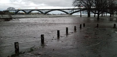
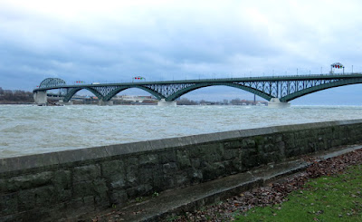
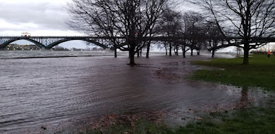
We have tried out a few trails this year: Welland Canal from Lock 3 to Port Colborne, Elora Cataract Trailway - Bellwood Lake to Elora, Elora Cataract Trailway - Bellwood Lake to Terra Cotta Conservation Area, Friendship Trail -Port Colborne to Fort Erie. And thanks to a great website called Ontario Bike Trails we have just started exploring trails like G2G - Guelph to Kissing Bridge in West Montrose. The website lists the rides, shows maps and provides information and reviews of the many trails in Ontario. Trails are identified for Mountain Biking, Rail, BMX and Parks. We are planning to ride the Oro - Medonte Rail Trail from Barrie to Orillia next year.
A friendly cat named Sandy came to us at the Kissing Bridge
Cottontail Road Trail shows the route to Elora

Thursday, August 27, 2020

Big Bend Lookout and the Big East River

The Big East River starts in Algonquin Park and heads to Lake Vernon near Huntsville, twisting and turning especially as it flows near and through Arrowhead Provincial Park. As the fast flowing water cuts through layers of sand it causes the formation of oxbow lakes and loops in the river and the lookout in the provincial park provides an outstanding view of one of the great loops in the river.


Arrowhead Provincial Park is 2.5 hours north of Toronto and is part of Ontario's primo cottage country called Muskoka. In addition to the camp sites and beaches, the park has two great points of interest - Big Bend Lookout and Stubbs Falls on the Little East River.

Panorama of Stubbs Falls on the Little East River

When rivers are allowed to determine their route (not constrained by man) they tend to follow the past of least resistance, from high elevations to low elevations. Sand does not stand up to the flow of water very well and erosion in sandy areas is quite extensive and the river meanders, causing some areas to be cut off from the river and be turned into oxbow lakes or even dry up, hiding the past river channel. Big Bend Lookout has large sand slopes along the outside of the curve, cut by the current, while sand is deposited on the inside of the curve as the water slows and the sediment falls out of the water. Erosion of the outer bend forces the park to move the lookout back from the edge each year. The view is similar to the famous Horseshoe Bend in the Grand Canyon.

Upstream launch point at Arrowhead Park Road adjacent to Highway 11
Cruising down the river

One of the reasons we came to Arrowhead was to kayak down the Big East River which flows fast enough that it is almost lazy river quality if you head downstream. We decided to drop the kayaks on Arrowhead Park Road adjacent to Highway 11. There is a small parking lot near Tulip Inn where you can park for free during the day. Then we parked our other vehicle at Hutchenson Beach at Lake Vernon which also had free parking. Light paddling and a stop for a barbecue lunch on one of the many sandbanks along the river had us completing the journey in about 5 hours and a distance of about 10 kilometres. It was a great journey and we hope to do it again next year. Highly recommended.

Stopping for a barbecue lunch on one of the many sand beaches along the Big East River
Spring runoff make for a powerful river. These steps got caught up on fallen trees

Update August 2021: We made it back to the Big East River, this time traveling down stream between Williamsport Road and Highway 11, passing through the famous Big Bend Lookout in Arrowhead Park. Last year we looked down upon the river and decided that we needed to put on our pirate hats and rest up on the sand bank below the lookout.
Pirates approaching the Big Bend

See more of the journey after the jump.

Doors Open

Scarborough Bluffs

Pride

Redball

Beaches

Graffiti

Lake Ontario

Nathan Phillips Square

Transportation